A local collector used old postcards to redraw Fresno’s transit history, showing lines, stops and the odd neighborhood that vanished. The fresno streetcar postcard collection he assembled isn’t just pretty pictures; it’s a working map of how the city moved people in the early 20th century. You can trace a route from downtown out to Sunnyside, see the interchange where riders switched cars, even find the tiny park that was a trolley turnaround before it was a parking lot.
## Fresno Streetcar Postcard Collection Reveals Forgotten Routes
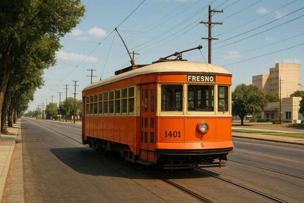
The collection contains dozens of cards with hand-colored streetcars, embossed studio stamps and penciled notes on the back. Many of those images were made when the system was expanding, between 1904 and the late 1920s. The fresno streetcar postcard collection includes examples that show route numbers painted on the cars and ads for local businesses printed right on the card faces. That kind of detail lets historians place a card to a specific year or even a service season.
### How Postcards Helped People Navigate
Postcards were cheap, plentiful and often doubled as wayfinding tools. A resident might mail one to a cousin and write, “Board at the depot, take the #7 to Ashlan, change to the Seventh Ave. line.” Those short notes matter. When you stack several cards from the same street corner across a decade, you begin to see schedule adjustments and track realignments. The fresno streetcar postcards often include street-level views that show signage, lamp posts and storefronts—small anchors that match city directories and Sanborn maps.
People collecting these cards aren’t just after nostalgia. They’re piecing together service footprints. One card in the colleciton shows a single-track spur to a cannery that disappears from municipal records after 1918; local newspapers corroborate a short-lived freight contract. A photo of a streetcar numbered 42, sitting under an awning with an ad for “C. J. Becker Groceries,” ties a car roster to a business address. That lets researchers confirm where lines ran and why certain suburbs grew.
#### A Note On Condition And Dating
Not every card is in mint shape; many are scuffed, torn or have corner bends. Those flaws can be clues. Postmarks and handwritten dates on the backs are obvious leads. The printers’ marks, paper stock and color palette help too. For example, glossy, highly saturated lithographs were more common in the 1910s, while earlier cards used simpler inks. Conservators can sometimes date a card within a few years by matching the paper chemistry to known batches.
### Mapping The City Block By Block
The practical thing the collector did was digitize the postcards and overlay them onto modern maps. By georeferencing the foreground buildings and track geometry visible in the images, he produced a layer that shows where historic lines ran. Comparing the layer with today’s streets highlights where rail corridors became boulevards, where medians still follow an old right-of-way, and where tracks crossed a river at a bend no longer used.
This mapping revealed tricky local details. One line skirted a creek to avoid steep grades; the overlay shows that the surviving sidewalk still follows the curve of the former rail bed. Another find: a cluster of postcards showing the same intersection across seasons lets you infer timetable density—cars in winter with snow-packed tracks, summer views with open windows and more passengers. Those visual cues help reconstruct frequency and rolling stock usage when official timetables are missing.
## Collector Stories And Where To See Them
Collectors and small museums in Fresno have been trading and exhibiting these cards for years. The most comprehensive private run was started by an electrician who grew up in a trolley family; he cataloged cards by route and attached transcribed notes from relatives who remembered driving or ticketing. Local archives now host rotating exhibits that put a few dozen cards on display with magnifiers so visitors can read the tiny backnotes.
If you want to study the collection, a few practical tips help. Handle cards with clean hands and minimal touching to the images. Take high-resolution photos rather than scanning on-site when museums restrict direct scans. Bring copies of contemporary maps from the early 1900s; matching street names matters because several Fresno streets were renamed. And expect to find duplicates—a popular view of the Depot was printed and distributed widely, so many holders own the same shot.
### What To Watch For In New Finds
Newly surfaced cards sometimes come from estate sales, boxes of letters, or old metal tins in attic rafters. A recently found lot included a sequence of streetcar postcards stamped in 1924 that showed a rare open-top sightseeing car used for seasonal events. That lot added a missing link between a service roster and surviving photographs of a parade.
Researchers looking to contribute should document provenance. Jot down who sold the card, where it was found, and any accompanying paper ephemera. When multiple cards show the same vantage point but different cars, the differences can be dated by livery changes or fleet numbers. Small discoveries like these collectively change how we understand Fresno’s growth and daily life.
The fresno streetcar postcard collection isn’t a static archive. It’s a set of working pieces that local historians, urban planners and hobbyists use to redraw the city’s transit story. If you love maps and old pictures, these cards are a direct line to how people once got around town—and how the city decided where to build next.