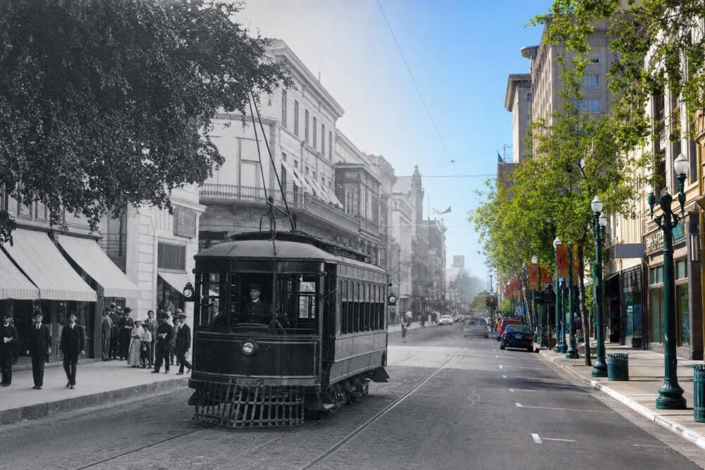
The first thing to notice is how predictable the empty tracks feel: scars on asphalt, a curve that still makes the street look like a different animal. Walk past enough intersections and you start to see the way people arranged their lives around the rails. That is the clearest entry to the story — not the schedules or the companies, but the small, persistent echoes left on the street grid.
## Fresno Streetcar History: Tracks, Power, And People
There’s a tidy narrative people like: streetcars arrive, the city grows, cars win, the lines vanish. Fresno’s story follows that arc, but the details matter. The earliest systems were messy, financed by local investors and speculative developers who wanted to sell subdivisions. Lines threaded through orchards, up dusty avenues, and into neighborhoods that later became blocks of houses with porches that face the old routes. Somewhere between the political fights over paving and the afternoon rushes of workers heading back from downtown, the streetcars changed how Fresno smelled and moved.
If you’re researching fresno streetcar history, you’ll find sources in the county archives, the postcard collections at the public library, and a surprising number of family albums. People kept photos of their kids on the platform, or of the conductor tipping his cap. Those pictures show cars with brass fittings and wooden benches, then later steel cars with electric motors humming under the floor. They also show how tightly knit transit and everyday life were: a grocer’s widow who rode the line to market, a teacher who commuted from a bungalow, a factory that synchronized shift times to the timetable.
### The Early Routes And Why They Mattered
Where a line goes is a practical decision with cultural consequences. Lines didn’t just serve places; they made them. Streets that looked marginal before the tracks were laid often became commercial strips within a decade. That’s obvious on a map, but it’s also obvious in property records: values jumped when a route was proposed.
In Fresno, routes funneled riders into downtown’s core, bringing customers to shops on Fulton and Mariposa. The tracks connected modest neighborhoods to civic institutions: courthouses, libraries, theaters. The streetcar was the artery that fed the downtown heart.
Work patterns changed, too. A family could move farther from a job and still expect to be there on time. That pushed development outward along the lines, creating corridors of denser housing and mixed-use blocks. Planners sometimes speak of transit corridors as if they’re modern inventions. Fresno’s earlier streetcars were doing that work a century ago.
### Technology, Maintenance, And The Small Economies Around The Rails
We tend to romanticize old transit, picturing shiny trolleys gliding on perfectly kept rails. The reality was more prosaic. Tracks needed constant tamping. Overhead wires required linemen who climbed poles in summer heat. Carbarns were busy, oily places where teams greased bearings, replaced worn wheels, and painted routes on the sides of cars.
Those jobs mattered locally. A neighborhood near a carbarn had steady employment. Repair shops, suppliers, even a café that served workers on breaks — these were small economies bound to the streetcar system. When lines were cut back, those ripple effects were immediate. Shops lost lunch crowds. A mechanic looking for work made the rounds and sometimes left the city.
That microeconomic perspective is part of fresno streetcar history that you don’t see in broad timelines. It’s in rent rolls and the lunch specials printed on a barista’s chalkboard photograph.
### Decisions, Politics, And The Mid-Century Decline
By mid-century, many American streetcar systems were under pressure. Private operators complained about rising costs and the difficulties of competing with private automobiles. City planners and politicians had mixed motives: some genuinely wanted more flexible bus services, others welcomed the ability to reconfigure streets for cars and parking.
Fresno was no exception. There were battles in council chambers and in newspapers. Some argued for modernization — replace aging cars with buses, spread asphalt where rails once were. Others preferred preservation of a system that still had steady ridership on many corridors. The debates often hinged on immediate budgets and political clout, not long-term urban form. When the cuts came, they tended to follow the path of least resistance: routes that served fewer influential neighborhoods disappeared first.
Those shifts changed downtown fundamentally. Streets that had been shaped by the flow of trolleys gradually reoriented to the rhythms of parked cars. Sidewalk life thinned. The downtown that once pulsed with exchange on weekdays began to look designed more for commerce by car than for human movement.
### Physical Traces That Still Tell A Story
If you pay attention, you can still find physical evidence. It’s not just the occasional patch of embedded rail that peeks through the pavement. Look for odd curbs that suggest a track alignment, or a flattened curb cut where the platform used to be. Some buildings betray their relation to the lines: a former storefront whose floor sits a step higher because the platform once abutted the door. There are carbarns that became warehouses or were gutted into lofts. A few surviving timetables and route maps end up framed in coffee shops.
Historical plaques are few. Most of the memory is oral. An older neighbor might point to the place where the conductor used to call, or tell you about a bridge where the trolley slowed to climb. That’s how fresno streetcar history stays alive — by being passed along with the stories of where families met and how people got around.
## Fresno Streetcar History Illuminates Downtown Echoes
Saying “the past matters” is cheap. What’s more useful is tracing exact ways past transit shaped downtown Fresno: which blocks became commercial, how intersections formed, where housing density clustered. That’s the kind of detail that helps planners and citizens understand why certain areas feel more walkable or why businesses still cluster along particular corridors.
I spent an afternoon walking one of those old lines. The route began in a dense stretch with narrow storefronts, moved through a liminal zone of former mixed-use buildings now converted to offices, then slipped into a residential pattern where porches face the street almost as if expecting a stop to arrive. The visual continuity was striking. It was a reminder that transport decisions from a century ago still guide human choices about where to open a café or a barbershop.
### Memory And Identity In Neighborhoods
Neighborhood identity often rests on small rituals related to transit. Annual parades that used to pause near a car barn, or a lunch counter that remembers shift workers from long-closed factories — those are the threads of civic memory. Some communities have embraced that memory explicitly; others keep it in quiet ways, like an oral history project or a brown-papered storefront with a handwritten note about the building’s past.
Preservationists occasionally propose heritage trolley loops as tourist draws. Those projects work best when they’re honest about scale and funding. A replica line can be charming, but it’s not a full transit solution. It can, however, serve as a living museum that reminds residents and visitors alike of the relationships between mobility and urban life.
There are also mis-memories. People sometimes remember their grandmother taking a specific line when the timelines don’t match. That’s part of what makes local history human. Oral accounts can be wildly colored; the trick is to compare them to maps and ledgers. Combined, the stories and records create a fuller portrait.
### Archival Sources And How To Read Them
If you’re serious about fresno streetcar history, look in a few places. Start at the city archives for ledgers and permits. Check the county assessor for property plats showing street widths and right-of-way easements. The local historical society often has company records, if the original operators kept them. Newspapers are invaluable; they carry route announcements, fare changes, and occasional public fights.
When you read these, be alert to what’s missing. Corporate archives may underplay labor disputes. City documents often frame cutbacks in terms of efficiency, while minutes from neighborhood meetings reveal the social costs. A timetable tells you scheduled headways. Payroll records tell you something about wages and employment stability. Together, they let you reconstruct both the mechanical and the human systems.
### What The Streetcar Left Behind In Land Use
There’s an urbanist lesson here: transit systems do more than move people. They anchor development. In Fresno, the legacy is visible in downtown parcels that remain relatively narrow and deep, a form that supports small shops and walkable street fronts. Compare that to the wide-lot suburban pattern that spread with automobiles; those parcels encourage drive-in behaviors and larger setbacks.
Understanding that makes a difference when thinking about contemporary downtown revitalization. If you want active frontage and an evening scene, you’d do well to work with the bones shaped by the old lines rather than trying to impose a different morphology. That doesn’t mean resurrecting every abandoned rail, but it does mean recognizing the traces that can be reactivated.
### The Relationship To Modern Downtown Fresno Transit
When modern planners talk about downtown revitalization, they talk about downtown fresno transit as a tool. Bus routes, bike lanes, and shuttle services try to stitch parts of the city back together, but they face entrenched challenges: limited funding, competing land uses, and the legacy of sprawl. There’s a recurring question: should Fresno replicate old streetcar lines, or design new corridors that respond to present-day travel patterns?
Both approaches have merit. Revivals that follow old alignments can tap into existing density and symbolic memory. New corridors can serve emerging centers like university expansions or new cultural districts. The point is to recognize that transit is not just technology; it’s a way to coordinate where people live, work, and spend their time.
I’ve listened to planners debate whether a heritage line could double as an actual commuting option. Practically, heritage trolleys are rarely fast or inexpensive enough to serve broad transit needs. But they can create focal points, attract investment along a corridor, and change perceptions of downtown mobility. They can make a street feel public again.
### Comparing Fresno To Other Cities
Fresno’s experience resembles other mid-sized American cities: early growth around rails, mid-century decline, and contemporary interest in transit-led redevelopment. But Fresno’s agricultural economy and the layout of its downtown give it unique contours. Seasonal labor flows, produce markets, and the rhythms of irrigation and harvest have all interacted with how people moved through the city.
Cities that have successfully integrated old transit legacies into new plans did two things: they accepted imperfect continuity and they treated the past as one of several tools rather than an idol. That means being willing to combine heritage elements with modern service standards, and to experiment with phased approaches that start small and scale up.
### Preservation, Adaptive Reuse, And Everyday Heritage
Adaptive reuse of former transit infrastructure has been uneven. Some carbarns become creative studios; others languish. The difference often comes down to ownership and entrepreneurial energy. A vacant building near a promising corridor is ripe for reinvention if someone sees a business model that fits the bones. Local incentives — tax credits, grants — help, but so does a culture that values small-scale risk-taking.
Everyday heritage matters. It’s not just plaques and museum exhibits. It’s the way a downtown bakery lines up its tables on a corner where a stop once catered to workers. It’s the family that runs a tailor shop in the same spot a conductor once stepped off. These small continuities matter for urban vitality.
### Stories That Refuse To Be Neat
History is messier than its timelines. There were tram strikes, yes, and there were also instances where lines expanded during economic downturns because a developer thought a push on service would stimulate housing sales. There were political deals in which route changes rewarded particular business owners. Those messy moments show how transit is always entangled with power and money.
When digging into fresno streetcar history, you’ll find conflicting accounts of a single route’s importance. One neighborhood might claim a line saved it; another might say the same line was the cause of displacement when commercial rents rose. Both can be true. Context matters.
### What A Revival Might Look Like
Talk of new street-level transit sometimes circles back to a heritage line or a modern streetcar. A thoughtful proposal would pair service planning with land-use tools: zoning that allows for higher densities along corridors, incentives for small businesses to occupy ground floors, and pedestrian improvements that make the first and last mile inviting.
There’s also a funding reality. Capital costs for rails and vehicles are high. A phased strategy often works: start with bus priority lanes and streetscape upgrades to build ridership and political will, then consider fixed-guideway investments where demand and development potential justify them. Preservation-minded planners also look to blended funding: local assessments, federal grants, private partnerships.
### Anecdotes That Make The Past Real
I met a woman who recalled riding a trolley to her first job at a downtown drugstore. She described the conductor’s whistle, the smell of orange blossoms in spring, and the way the car slowed at a particular crosswalk where her father waited with a lunch pail. Those details are small, but they animate teh broader narrative in a way that ledgers don’t.
An old repairman once told me that wheels were the least glamorous part of the job: “You learn the city by the sound of the rails,” he said. That’s a sensory memory, the kind that doesn’t make it into official histories but which tells you how embedded the system was in everyday life.
### The Unsettled Present
Modern efforts around downtown fresno transit keep bumping into historical patterns of development and political influence. Redevelopment proposals meet residents who remember being left behind by previous waves of change. Developers look at old streetcar alignments and see potential, but they also see infrastructure costs. The tension is ongoing.
There’s no single answer that restores the old system wholesale. But studying fresno streetcar history gives tools for making better choices about where to invest in mobility and how to ensure those investments benefit a wide range of city residents. It changes the conversation from nostalgia to practical design — and it reveals small, specific places where interventions could shift outcomes.
#### A Walk That Teaches More Than A Map
Take one of the remaining corridors on foot. Note how storefront depths, door placement, and sidewalk widths relate to where stops would have been. Think about the hours of the day when the street feels alive. That’s the same kind of empirical testing planners used to do, only now it’s done with a phone camera and a notebook instead of a clipboard and a stopwatch.
There are plans and proposals, and historic photos pinned to corkboards in local offices. There are also people who still measure distances in blocks that once took ten minutes by trolley. That oral metric is part of the city’s memory.
#### What You Find In The Margins
Side streets often hold the richest evidence. A narrow alley might have been a loading zone for a transfer. A brick wall sprayed with old paint layers can tell you about signage and design taste across decades. These margins hold the small stories that link systems to lives.
If you want to dig, check zoning changes over time. They reveal when a city decided it wanted a different kind of downtown — one less dependent on rail and more on cars and parking. Those zoning documents are a kind of confession: a record of choices that shifted the city’s shape.
The study of fresno streetcar history is not an academic exercise only. It is also a practical way to see how past investments shaped present possibilities, and how those possibilities might be nudged toward more walkable, equitable, and lively uses of downtown space. The rails themselves might be gone in places, but the echoes are not — and they still matter to anyone trying to make the downtown of today work better for tomorrow.